


Northern VA Accessible Trails
Alexandria
Cameron Station Linear Park
5131 Brawner Place, Alexandria, VA
Description: A 1 mile neighborhood trail offering an asphalt-paved pathway used by joggers, dog walkers, families and bikers out for a leisurely ride. At either end is a popular park with a playground, rest rooms, and picnic tables: Ben Brenman Park on its east end and Armistead Boothe Park on its west end.
Directions: Parking can be found in Ben Brenman Park (4800 Brenman Park Drive) on the trail’s east end and Armistead Boothe Park (520 Cameron Station Boulevard) on its west end.
Additional Information: If you want a longer trip, you can go across Ben Brenman Park, crossing a bridge over Holmes Run on the park’s east side, and connect to the Holmes Run Trail, a 5 mile tail which parallels the waterway.
Holmes Run Trail
5131 Brawner Place, Alexandria, VA
Description: The Holmes Run Trail is a 5-mile asphalt and concrete scenic pathway through the heart of a busy residential area in Alexandria and adjoining Fairfax County. The paved trail begins next t to Cameron Run Regional Park and Great Waves Waterpark in western Alexandria.
Directions: Interstate 495, exit 174 (Eisenhower Avenue Connector). At Eisenhower Avenue, turn right (east) and go approximately 0.5 mile. Cameron Run Regional Park and Great Waves Waterpark will be on the left. From the parking lot go to the Vola Lawson Animal Shelter, you’ll encounter the southern trail head for the Holmes Run Trail. Parking and public rest rooms are also available in Ben Brenman Park (4800 Brenman Park Drive).
Additional Information: The trail follows a small stream, where you're likely to see geese and other waterfowl, and past Ben Brenman Park, which offers a playground, rest rooms, picnic areas and parking. Bring your own water as there is no access to water fountains.
Alexandria, Arlington, Fairfax
Mount Vernon Trail
http://www.nps.gov/gwmp/planyourvisit/mtvernontrail.htm
Description: One of the Metro area's most popular trails, this 18 mile asphalt and boardwalk trail links Theodore Roosevelt Island Park with George Washington's Estate in Mount Vernon. The trail follows the course of the Potomac, passing through parks, yacht clubs, wetlands, neighborhoods, towns and wooded acres. It is heavily used by cyclists and pedestrians, especially on weekends.
Directions: The three main access points are:
Theodore Roosevelt Island: Access via the northbound lane only of the George Washington Memorial Parkway. Parking can be limited on weekends.
Old Town Alexandria: Access from I-495; take the Patrick Street/US 1 Exit north and follow the signs to downtown. Or take I-395 to the King Street/State Route 7 Exit and head east (south), following the signs into town.
Mount Vernon Estate: Access at the southern terminus of the George Washington Memorial Parkway.
Additional Information: Old Town Alexandria presents an interesting diversion with waterfront parks, restaurants and shops. The marina boardwalk area is lively, with all kinds of entertainment year-round.
Near the Mount Vernon Estate, the trail begins a steep climb through the forest where it ends in the parking lot for the estate grounds. At the northern end of the trail, at the parking lot for Roosevelt Island, you can explore the island park's ring trail via a footbridge over the river. Also, from here, you can take a pedestrian bridge over the road and pick up the Custis Trail.
Link to Trail map in PDF format.
Arlington
The Bluemont Junction Trail
http://parks.arlingtonva.us/locations/bluemont-junction-park/
744 N Emerson St. Arlington, VA 22205
Description: A short asphalt-paved trail that branches off from the popular Washington and Old Dominion Trail (W&OD) in the heart of Arlington, it is 1.3 miles long.
Directions: The trail can be accessed from Bluemont Junction Park, where parking is available. To reach the park, travel west from Washington, D.C., on US 50 and turn right onto N. Manchester Street. Follow the road for 0.25 mile until it dead ends, and turn right into the parking lot. From Ballston, travel southwest on Wilson Boulevard, and turn left onto N. Manchester Street. Take an immediate left into the parking lot.
Additional Information: Bluemont Junction Park has exhibits on local rail history. The park also has picnic areas, playgrounds, ball fields and tennis courts.
Fairfax County
Cross County Trail
Description: It is a 40 mile multi-use trail that generally follows the various stream valleys in Fairfax County, Virginia.
Some sections are wheelchair/mobility scooter accessible but not all sections. Approximately four miles of paved trail runs from the north end of Wakefield Park (Americana Park) to Thaiss Park in the City of Fairfax. From Wakefield to King Arthur the trail is either eight foot wide asphalt or 10 foot wide concrete. Beyond that point to Thaiss Park, the trail is mostly six to eight foot asphalt, but there are a few sections of stonedust.
Directions: The trail can be accessed at numerous places along its route. The most convenient and popular place, with plenty of parking, is from Wakefield Park and Audrey Moore Recenter, 8100 Braddock Rd., Annandale (about the halfway point).
Additional Information: Trail users will see lots of wildlife, such as deer, fox, muskrat, amphibians, and many species of bird, including hawks and owls.
Huntley Meadows Park
Description: An urban park of over 1,500 acres of forests and wetlands, it has paved wheelchair accessible trails, boardwalks, and viewing platforms. There is half-mile boardwalk wetland trail, a 2-mile interpretive trail system, and several wildlife observation platforms.
Directions: Take the George Washington Memorial Parkway, travel 1.2 miles and make a sharp right on SR 235 North/Mount Vernon Highway. Drive 2.0 miles and turn right on US 1 North, continue 1.4 miles, and turn left on Lockheed Boulevard. The Huntley Meadows Park entrance is 0.6 miles on the left, directly across from Harrison Lane.
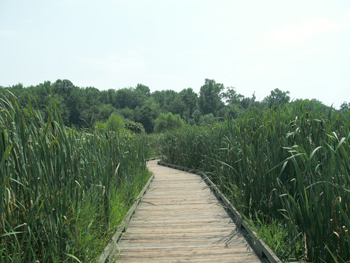
Photo by AlbertHerring
West Ox Road Sidepath
Description: This is a 3 mile asphalt-paved trail along the west side of West Ox Road. The trail goes from the Oak Hill area of Fairfax County to southeastern Chantilly, near Fair Oaks Mall in Fairfax, providing a link to numerous neighborhoods along its route.
Directions: West Ox Rd./SR 608 and Penderbrook Dr. (Chantilly) to West Ox Rd./SR 608 and Franklin Corner Ln. (Oak Hill)
Fredericksburg
Mary Washington Hospital Trail
Description: A short, concrete trail about 3/4 of a mile that runs along the southeast border of the hospital center. proving a pleasant stroll or gentle bike ride for hospital visitors and patients.
Directions: Park at Mary Washington Hospital, 1001 Sam Perry Boulevard, Fredericksburg, VA. Parking restrictions may apply.
Railroad Ford Trail
Description: Located in Lake Anna State Park in Spotsylvania County, this 1 and half mile packed dirt loop trail is rough but wheelchair-accessible.
Follow the sidewalk past the visitor center and boat-rental area, and the trail begins where the sidewalk ends. Bear to the right the 0.75 mile trail takes you along a packed dirt path that runs along side Lake Anna. You can take many short paths to reach the water's edge, where you can access one of the many benches along this stretch. When the trail bears left after less than a mile, it becomes wider, elevated and flat.
Directions: Interstate 95 to the Thornburg Exit (Exit 118) and travel west on State Route 208 and follow signs to Lake Anna State Park. Drive, about 11 miles on SR 208. After passing a high school on your left, the road takes a sharp left turn. You will see a pretty white farm house on the corner and a sign for the state park indicating you should follow SR 208 and bear left. Go approximately 7 more miles and turn right onto SR 601. Travel 3.3 miles and turn left into Lake Anna State Park.
Additional Information: There is a park entrance fee.
Rappahannock River Heritage Trail
Link to trail information with photos.
Description: This is a one and a half mile paved trail in the center of Fredericksburg with scenic views of the Rappahannock River. Part of the trail winds through Old Mill Park, where you can find parking, picnic shelters, and rest rooms
Directions: 3008 Normandy Avenue Fredericksburg, VA 22401
Additional Information: Trail begins at Fall Hill Avenue and ends at Princess Anne Street. Parking is available in Old Mill Park (2410 Caroline Street).
Virginia Central Railway Trail
Link to Trail Map in PDF format.
Description: The trail has almost miles of asphalt or concrete trail across two disconnected segments: one from downtown Fredericksburg to the Idlewild neighborhood.
Directions: To access the Fredericksburg segment enter the Harrison Road Convenience Center at 5917 Harrison Road in Fredericksburg, and turn right toward the ball fields at the top of the hill. The trail head is at the far end of the parking lot.
Additional Information: The trail runs from the eastern end of the Cobblestone development off Lafayette Boulevard out Lafayette Boulevard and across the Blue and Gray Parkway, then through Alum Spring Park and across Jefferson Davis Highway (Route 1) to a point near the Idlewild neighborhood, just east of I-95.
Prince William
Sudley Manor Drive Trail
Description: Located in western Prince William County, the4 mile asphalt trail services a number of the surrounding communities, such as Bristow and Bull Run, and acts as a recreation and transportation route for the local residents.
Directions: Vint Hill Rd./SR 215 and Sudley Manor Dr. (Bristow) to Chatsworth Dr. and Sudley Manor Dr. (Bull Run)
Additional Information: The best portion of the trail is from roughly University Blvd. to Linton Hall Road. Prince William County Parkway is a heavily traveled road and there is a wait for traffic to clear.
Rosslyn
Custis Trail
http://bikewashington.org/trails/wad/custis.htm
Description: The asphalt and concrete trail is a popular urban route that is 4 miles long. It can provide a real workout as the hills are challenging and more so if you are traveling east to west. Parts of the trail ware through wooded areas, while other parts were side roads to major roadways.
Directions: Public and paid parking is available in Rosslyn and free parking is available at Roosevelt Island parking lot off George Washington Parkway (access only heading N/W bound). You can also park at Bon Air Memorial Park in Arlington.
Additional Information: Beginning in Rosslyn at the intersection of Lee Highway and Lynn Street, the trail follows a wide sidewalk up the hill as it heads west. Beyond the Key Bridge Marriott Hotel, the trail turns to asphalt and becomes more narrow.
Warrenton
Warrenton Branch Greenway
Description: This one and half mile asphalt paved a segment of the old Warrenton Branch Spur railroad, runs between the trail head behind the restaurant at the depot in downtown Warrenton (4th St. near Lee St.) and Castle Kingston Lane just east of the Bypass (US 15/17/29) with lots of shaded areas and beautiful paved walkway.
Directions: Parking is available at the depot off 4th Street in downtown Warrenton and at the end of Castle Kingston Lane, west of the Bypass.
Additional Information: It is great trail for railroad history buffs as there an old turntable and a retired caboose, donated by the Norfolk and Western Railroad.
White's Mill Trail
Link to map of trail in PDF format.
Description: A short, asphalt-paved trail, less than 2 miles long through wetlands and residential areas in the scenic town of Warrenton.
Directions: From Mill House Lane to Movern Lane.
Additional Information: Parking is available in the cul-de-sac just beyond Baymont Inn and Suites off of Route 29 north of Warrenton. The trail head is located down a gravel road, but please don't park along gravel road as it is a private street.
<<<back to Accessible Trails
Home | Regions | Virginia Weather & Maps | Resources | Outdoor Recreation | About Us | Contact Us | Accessibility Links

