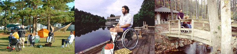


Central Virginia Accessible Trails
Charlottesville
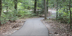
Mint Springs Park
Description: This Albemarle County Park is made up of two lakes stocked with largemouth bass, sunfish, channel catfish and bluegill. There is a wheelchair- accessible fishing pier, a wheelchair accessible playground, and picnic areas, along with rest room facilities. The best trail goes around the lake with access to the pier and playground. The others are grass and rocky, going from the lake to the top of the mountain.
Directions: 6659 Mint Springs Park Road, Crozet, VA 22932 Take Route 250 West; Turn right onto Route 240; Turn left onto Route 788 (Rail Road Avenue); Turn right onto Route 684 (Mint Springs Road); Turn left into Park.
The Saunders Trail at Monticello
Description: Owned and operated by Monticello, this two-mile trail winds two miles up Carter Mountain to the entrance to Monticello, the home of Thomas Jefferson. It never exceeds a five percent incline making it one of the few wheelchair accessible mountain climbs in the state. It’s paved with finely crushed, packed stone and partly of raised boardwalk. The round trip is 4 miles.
Starting at the bottom of Carter Mountain at the Kemper Park and Arboretum. The Saunders Trail meanders through woods, passing by a small manmade pond, and offers spectacular views of towering hardwood forest, ravines and of the Blue Ridge Mountains.
It's mostly downhill if you start from the Monticello visitor center and only go one way. If you don't want to make the trip back up the mountain, then you'll have to have someone meet you at Kemper Park.
Saunders Trail in the Spring Time
Photo courtesy of Monticello
Directions: From I-64 in Charlottesville, take Exit #121 and head south on SR 20 for 0.6 miles to SR 53/Thomas Jefferson Parkway. Turn left on SR 53/Thomas Jefferson Parkway. Go about 300 yards, turn right into trail head parking lot. The entrance to Monticello is approximately 1.5 miles further along SR 53.
Additional Information: Free and open to the public all year, sunrise to sunset. No restroom or drinking facilities are currently accessible. It's a cool, shady trail in the summer, beautiful in the fall when the foliage is changing colors, and breathaking in the spring when the redbuds and dogwood are in bloom. Monticello, the home of President Thomas Jefferson, is a must see part of the trip.
Danville
Richmond and Danville Rail-Trail
Description: This trail is 5 and a half miles long and made of crushed stone that’s wheelchair accessible. It follows an important transportation corridor for the Confederacy during the Civil War that linked Richmond and Danville where hospitals, prisons and supply depots were located. Today the trail goes past farmlands and woods in a flat route in the countryside bordering Danville so this trail is easy ride, level and shaded enough to be comfortable on a hot day.
You can start your trip at the western end at the Ringgold Depot and in about a mile you will reach an area that’s great for watching waterfowl. Plaques along the way explain significant Civil War events that happened near the trail. The eastern trailhead has a restored railroad depot and an old red caboose.
Directions: From Danville, take US 58 east for about 2.5 miles then head north on State Route 734/Ringgold Depot Road for 3 miles. The western trailhead is located on the south side of Ringgold Depot Road.
To access the eastern trailhead, continue east on US 58 for an additional 3.75 miles then head north on Hackberry Road/State Route 656 for 3.25 miles. The trailhead is west of Hackberry Road/Kerns Church Road near the intersection of Kerns Mill Road//CR 948 (Sutherlin)
Additional information: Be prepared with bug spray. If you start at the eastern end at Kerns Mill Road, be careful because it is not well marked. If you are coming from the north on Rte. 58 up Rte.656 at approx. 3.2 miles there is a parking lot on your left hand side. The marked "dead end road" Railroad Trail is on the right just before the lot.
Riverwalk Trail
Description: This charming trail along the Dan River is a concrete and asphalt trail connecting industry, parks and natural areas. The length is a seven and half miles going through an area rich with Civil War history. Danville was the last capital of the Confederate States of America after Richmond was captured by the Union army, but was an important tobacco and manufacturing center.
The best starting point is in downtown Danville, at a renovated tobacco warehouse and the Amtrak station located in the Science Center, crossing the Dan River on a restored 1856 railroad bridge. At the end of the bridge, you can go east or west.
The western trail is to your left and follows the river upstream for about 1 mile reaching the overlook at Union Street Bridge. If you go further s upstream you’ll get to businesses and restaurants.
The eastern trail is to your right and takes you through the many parks and natural areas along to the Dan River. You'll see a wildlife, including geese, ducks and blue heron.
At the Dan Daniel Memorial Park, the trail winds along the river through Angler's Park. At the Angler's Park trailhead, you can continue on the trail segment toward Danville Regional Airport, but the trail is from this section to the airport, and it is the most secluded section of the Riverwalk.
Directions: To reach the downtown starting point, take US 58 Business to downtown Danville, go to Main Street south across the Dan River and make a left on Craghead Street. Follow that for about 5 blocks until you see signs for the train station on the left. The trail beginning will be on the far side of the parking lot.
For the eastern trail, parking is available at Dan Daniel Park, 302 River Park Drive, and Anglers Park on Northside Drive.
Additional information: The trail is very smooth, very flat and very scenic. The western trail leads to the old mill district with these gorgeous old red brick warehouses. The eastern trail has numerous benches, picnic tables, and pull off areas to enjoy the flowing river, the trees, green grass and a variety of waterfowl. So you can experience the best of both urban and rural in one location.
Farmville
High Bridge Trail
Link to trail guide in PDF format.
Link to video showing the trail.
Description: Home to the longest recreational bridge in Virginia, it is among the longest in the United States. During the Civil War, both Union and Confederate armies attempted to destroy the bridge to prevent the other side from crossing the river.
High Bridge Trail State park runs 32 miles through Cumberland, Nottoway and Prince Edward counties and the towns of Burkeville, Farmville, Pamplin City, Prospect and Rice. The trail is made up of finely crushed limestone and the center piece of the trail is the High Bridge, which is more than 2,400 feet long and towers 125 feet above the Appomattox River. There are sheltered benches along the way. Breathtaking views of the surrounding countryside combined with the accessibility makes this trail a popular destination.
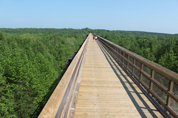 Photo by Virgina State Park Staff
The best place to access the trail is Farmville, where the marvelous bridge is less than 5 miles from downtown. Follow the wide, gentle grade of the former South Side Railroad, a spur off the Norfolk Southern Railway. Plus the downtown offers municipal parking, coffee shops, diners and cafes, historic buildings, and public restrooms.
Directions: Park at the Main Street plaza parking lot in Farmville; the bridge is 4.5 miles. For a shorter trip, there is a closer parking lot about a mile from the bridge at River Road ($3.00 fee to park)
Additional Information: If you want a longer excursion, the trail extends outward from either end of the bridge, totaling more than 30 miles through woodlands and farmland. Restrooms are available along the way. Some sections are remote so be sure to bring a cell phone and keep track of where you are on the mileage markers and pack drinking water.
To access the trail, parking is available at the following locations (west to east); a fee is required.
Near Pamplin: Heights School Road off U.S. Business 460, is near trail milepost 168.
The three-mile section of the trail to Elam with picnic tables and accessible bathrooms along the way is an easy trail of packed stone among tall pines where you can see deer and other wildlife.
 Photo by Virgina State Park Staff
In Elam: Off U.S. 460 at Sulpher Spring Road, near trail milepost 164
The trail from Elam to Prospect is a 3 and a half-mile portion going by green pastures and ponds where you may see concrete mile markers used by train conductors to know how far they were from Norfolk.
In Prospect: Prospect Road off U.S. 460, near trail milepost 161 has wheelchair accessible parking.
Close to 4 miles long, the trail from Prospect to Tuggle is a level path of packed limestone. There are parking, bathrooms, and a picnic area just off of Prospect Road and a gas station for food or drink. While traveling you may see Christmas Ferns, which stay green year round.
In Tuggle: Tuggle Road off U.S. 460 and near U.S. 15 North, near trail milepost 156
It’s a little over 5 miles from Tuggle to Farmville. While the trail does have bathrooms, parking and picnic tables just off Tuggle and Hard Times Roads, it also has steep drop offs on either side of the trail with no guard rails. Be aware of where you are as you look at the interesting shale rock formations along the way.
In Farmville: In the municipal lots (wheelchair accessible parking) where the trail intersects Main Street, near trail milepost 150; 0.25 mile off N. Main Street, near trail milepost 149; and River Road, 3 miles off N. Main Street, near trail milepost 146.
As noted, in the description above, this three and a half mile of the trail is the most important as accessing the High Bridge.
In Rice: Depot Road, 0.25 mile off U.S. 460, near trail milepost 142 has wheelchair accessible parking.
The trail from High Bridge to Rice is a 3-mile section woods with occasional road crossings. US 460 has a lot of traffic, but the trail crosses over it via of a fenced in bridge close to the town of Rice Restrooms are available.
La Crosse
Tobacco Heritage Trail
Description: The entire trail is 17-mile trail between the southern Virginia towns of Lawrenceville, Brodnax and La Crosse, but only the three-mile section, from La Crosse to Brodnax is asphalt paved, making it about a 6 mile round trip. It’s a smooth easy trail, ideal for families, strollers, and those using wheelchairs. You will first see the town businesses, churches, and residences before entering the woods with local wildlife.
You will also go past an abandoned tobacco barn near the regional airport, a symbol of the farming that sustained this area of Virginia. Mile markers are placed every half-mile and there are nice interpretive signs about the local history and birding.
The first loop of trail ends at the regional airport, where there are benches, and trash cans, before you start your return trip into LaCrosse. Be sure to visit the antique caboose in the center of town.
Directions: From I 85, take US 58 into La Crosse. A trail begins at SR 618 with free parking is available the trail beggining or at 115 South Main Street.
Lynchburg
James River Heritage Trail
Link to trail map in PDF format
Link to another trail map in PDF format
Description: One of the leading city trails in the state, this trail is slightly less than 10 miles long. It goes through forests and downtown Lynchburg, offering easy connections to other trails along the way. It’s a group of connected shorter trails: the Blackwater Creek Bikeway, the Point of Honor Trail, the Kemper Station Trail, the Riverwalk and the Percival's Island Trail. All are well marked with trail and mileage signs.
The best place to begin is at the Blackwater Creek Bikeway at the Ed Page trailhead on Old Langhorne Road. The Awareness Garden is a lovely spot and is dedicated to persons with cancer. The trail goes along an old railroad grade for 3 miles to Jefferson Street downtown and crossed the Blackwater Creek Natural Area. You may want to keep on the paved trail as the unpaved trails into the woods are for mountain bikes and lead down a steep bank to the creek. The trails are clearly marked.
Near mile 2, just after going under the railroad bridge, the trail divides. The left becomes the Point of Honor Trail, which is slightly less than 2 miles miles long, and the right becomes Kemper Station Trail, 1 mile long to the Kemper Street Station. To return to the main trail, you'll have to backtrack.
The James River Heritage Trail goes for another 1.25 miles along the river until it ends less than a mile past the last trail access point located off of Fertilizer Road. When you reach the endpoint, the railroad corridor continues but the trail becomes a dirt track.
You can access the James River Heritage Trail from many other places along its route. Drop by the Lynchburg Visitors Center (216 12th Street; 800-732-5821) for detailed maps of the trail system.
Directions: To reach the beginning of the Blackwater Creek Bikeway trail, go north on US 501 Business, which becomes Langhorne Road. Be on the lookout for a quick right turn onto Old Langhorne Road; the trail beginning is on the left.
To begin the trail at Fertilizer Road from the Lynchburg Expressway, take State Route 210 east to Fertilizer Road and turn right to follow it all the way the trail for parking.
Additional Information: On Blackwater Creek Bikeway, is the half-mile long Hollins Tunnel that is well lit, but water seeps from the ceiling. Be careful on crossing the spillway the Point of Honor Trail when water is flowing over top. You can cross above at the road if it's too high and fast.
At mile 3 (3.75 if you take the Point of Honor Trail) the Blackwater Creek Bikeway connects with the Riverwalk. This is a 1-mile trail along Jefferson Street's sidewalks to Washington Street. If you turn left (north) at Washington Street), cross the tracks and continue on, this trail becomes the Percival's Island Trail. This trail has a fantastic refurbished railroad bridge onto the island where there is a lovely overlook for views toward the river and downtown.
The Percival's Island trail covers the 1-mile-long island before crossing a second former rail bridge to the eastern shore of the James River. The mainland trail is surrounded by private property and signs warn you to keep to the trail to avoid trespassing.
Martinsville
Dick & Willie Passage Rail Trail
Description: This asphalt trail runs for 4 and a half miles on a former Danville & Western Railroad rail bed. The railroad was nicknamed the "Dick & Willie" after its initials. The trail goes through downtown Martinsville with underpasses and restored trestles providing safe crossings of busy roads. There are just two crossings involving traffic and they are on rural roads.
The western part of the trail ends at Villa Heights, near a supermarket and Mexican restaurant. If you end your trip in the eastern section, the trail ends at scenic overlook of Mulberry Creek in the secluded woodlands so you need to turn around and return to Martinsville. There are benches along the trail giving opportunities to rest and take in the beautiful sights. There are plaques with historical information along the trail.
You can access another nice trail, the Uptown Spur Trail, at Pine Street in Martinsville that leads into the city's downtown. Benches along both trails provide opportunities to relax and take in the beautiful surroundings.
Directions: Virginia Ave. north of Commonwealth Blvd. (Villa Heights) to Mulberry Creek Overlook northeast of Fishel St. (Martinsville)
Additional Information: Parking is available off Virginia Avenue/US 220 Business in Villa Heights at the parking lot from the shopping center at the corner of Virginia Avenue and Commonwealth Boulevard.
Parking and restrooms are available in Martinsville at the intersection of Liberty Street and Stultz Road; Doyle Street and Hooker Street; and Fisher Street and Fishel Street where you can see what remains of the original trestle.
Uptown Spur Trail
Description: This short, asphalt trail is slightly less than one mile in length going along an abandoned railroad spur line going into downtown Martinsville. It connects to the Dick & Willie Passage Rail Trail at Pine Street.
Commonwealth Boulevard/State Route 457 is a busy street, but a concrete trestle offers a safe crossing just before the trail’s northern end off Franklin Street. You will see, the Commonwealth Centre, an office and warehouse complex, that has been converted from a former textile factory that was originally a tobacco factory and later a cotton mill.
Directions: Pine St. to Franklin St. north of Commonwealth Blvd./SR 457
Additional Information: Parking is available at Depot Street in the heart of Martinsville. Restrooms are available.
Randolph
Staunton River Battlefield Rail-Trail
Description: The one and a quarter mile crushed stone trail follows an abandoned corridor of the old Richmond and Danville Railroad crossing though the Staunton River Battlefield State Park. It features some wonderful refurbished trestles spanning the Staunton River.
The trail begins at the Clover visitor center near the park entrance. You will cross three railroad trestles with the trail going through meadows and wetlands before reaching the Roanoke Station visitor center, a restored railroad freight depot, in Randolph. There are nice picnic sites on the bank of the river and on the north end in Randolph. Both visitor centers have restroom facilities, water, and parking, but the operating hours vary.
Directions: From South Boston to the Clover visitor center, take US 360 and turn north (left) on State Route 92 to Clover. Go about 5 miles and turn left on SR 600. In about 3 miles, look for the sign to the park, and turn right on SR 855 into the entrance.
From South Boston to the Roanoke Staton visitor center in Randolph, take US 360 to Branch Road/SR 608 and turn left. Follow it to the junction with Roanoke Station Road (SR 607) and turn left. Continue all the way to the trail beginning on your left in Randolph.
Additional information: The state park actually has two visitors centers, a museum, and a Civil War fort. Here a small group of Confederates were able to hold off the Union soldiers who hoped to destroy the main trestle to cut off a crucial Confederate supply line leading all the way to Richmond and save the trestle.
Richmond
Dorey Lake Park
Description: A popular lake in eastern Henrico County, this park has paved walking trail along the entire shoreline and a large wheelchair accessible fishing pier. The lake is stocked with trout and channel catfish. A picnic shelter is located by the parking lot at the north end of the lake, and there are also accessible restrooms near the lake.
Directions: 2999 Darbytown Rd, Henrico, VA 23231. From Sandston on Laburnum Avenue and then turning left (east) on Darbytown Road. The entrance to the park will be on the right. The official visiting hours for the lake, as well as the park, are sunrise to sunset, year round.
Rockwood Park
Descripton: This county park has a variety of facilities with picnic shelters, nature center, and a system of trails behind the center, several of which are paved for wheelchair access. The trails go through wooded areas with ample opportunities for birdwatching, especially for woodpeckers.
Directions: 3401 Courthouse Road Richmond, VA 23236. From Richmond, take SR 76/Powhite Parkway South to Courthouse Road in Chesterfield County. Turn left onto Courthouse Road/Rt. 653 and travel 1.4 miles. Rockwood Park is located south of the Powhite Expressway just before reaching Hull Street (US 360). Turn left into the park.
Pocahontas State Park
Gateway Trails
About 2:14 into the video is a demonstration of the handcyle and the trail.
Description: This are off-road biking trails designed for people with disabilities. For those using “purpose built” for adaptive bikes, often called handcycles or trikes, these series of trails are smooth, hard-packed clay. There’s banked turns and a succession of mounds called rollers that thrust you forward where you feel like you're on a roller coaster. There are more trails being developed in the next few years.
Additional Information: These trails are better suited for active, experienced bikers, but Gateway 2 is 1/2 mile long so this may be a better choice for those who are new to the sport.
Spilway Trail
Description: A 3/4 mile wheelchair accessible asphalt-paved trail winding though woods from the CCC museum to an overlook of the Beaver Lake dam. There are several benches with views of the lake located along this short trail. Early mornings and late afternoons are good times to watch for beavers as they show visitors what it means to be "busy as a beaver."
Directions: 10301 State Park Rd Chesterfield, VA 23832
From Interstate 95 south of Richmond: Take exit 61 onto Route 10 west, then left onto Route 655 (Beach Road). Go about four miles to State Park Road, which is on the right.
From Interstate 95 north of Richmond: Take Interstate 295 south to Route 10 west (Iron Bridge Road) to Route 655 (Beach Road) to State Park Road.
From 64 west of Richmond: Take Route 288 south to Route 10 east (Iron Bridge Road) to Route 655 (Beach Road) to State Park Road.
From 64 east of Richmond: Take Interstate 295 south to Route 10 west to Route 655 (Beach Road) to State Park Road.
Additional Information: There is an entrance fee. Link to trail map.
Virginia Capital Trail
http://virginiacapitaltrail.org/
Link to interactive trail map.
Link to trail map in PDF format.
Description: This is a 52 mile paved pedestrian and bicycle trail that connects Richmond and Jamestown along the Scenic Route 5 corridor.
The Richmond Riverfront segment, at the northern end of the trail, begins at the Canal Walk and ends at Great Shiplock Park, which commemorates the canal lock built here in the 1850s. It goes through Shockoe Bottom, one of the city's oldest neighborhoods.
The Varina part goes by Henrico County’s Four Mile Creek Park, a wooded outdoor park that was named for Varina Farms, a plantation established by early English settler John Rolfe, who married the famed Pocahontas.
The Park Phase is s a 3.5-mile horseshoe going away from State Route 5, connecting wit Dorey Park, a popular spot with many recreational amenities, including a playground, sports fields, tennis courts, disc-golf course, picnic areas, a nature trail, a fishing pond, and an off-leash dog park.
The New Market Heights portion runs near the Shirley Plantation, one of the oldest plantations in the state and a National Historic Landmark.
The Charles City County section passes many colonial plantation homes, including two presidential homes, Sherwood Forest Plantation, home of President John Tyler, and Berkeley Plantation (just off Harrison Landing Road). home of Presidents William Henry Harrison and Benjamin Harrison.
The Chickahominy Riverfront part starts at the intersection of SR 5 and Greensprings Road (SR 614) and goes to the Chickahominy Riverfront Park. You will see lovely views of the James and Chickahominy Rivers.
The southern end of the trail is the Greensprings segment beginning near the Jamestown Settlement. It gives a glimpse of early American history, Revolutionary War battlegrounds wooded wetland and wildlife along the way.
Directions: Park at Richmond Riverfront at Great Shiplock Park (intersection of Pear and Dock Streets); Varina at Four Mile Creek Park; Herring Creek Park segment at Dorey Park (2999 Darbytown Road); Charles City County Visitors Center (10760 Courthouse Road); Chickahominy Riverfront Park (1350 John Tyler Memorial Highway) or Jamestown High School (3751 John Tyler Highway); Jamestown Trail head off SR 31.
Additional Information: Amenities for the various sections of the trail are available as follows: Charles City County Visitors Center has rest rooms, Chickahominy Riverfront Park has rest rooms and picnic areas are available in the park, and Greensprings has rest rooms and picnic tables.
Trail markers every mile keep you feeling very connected to where you are. It's a long trail and on the Varina to Richmond section and the Charles City to New Market section, there aren't a lot of places to refill water bottles, go to the bathroom, or buy food.
There is plenty of trail head parking at various spots along the trail for shorter rides.
<<<back to Accessible Trails
Home | Regions | Virginia Weather & Maps | Resources | Outdoor Recreation | About Us | Contact Us | Accessibility Links

